Introducing Autonomy Realms Through Live Demonstration

Failed to load video
Chapters
Transcript
[0:00] Hi there, I'm RSW Fire and I'm here to introduce you to Autonomy Realms.
[0:08] It is software and infrastructure that I built first for myself and then for others.
[0:16] It's a way of organizing your digital life and allowing artificial intelligence to process
[0:27] it and analyze it and reflect on it and create data about it and a way for you to share that
[0:39] data with others and with artificial intelligence in a variety of ways.
[0:48] It's really difficult to explain what I built without just showing it to you.
[0:55] There are so many different ways that someone might find it useful in their life that aren't
[1:01] obvious, but I think that if I take you through how I built it for myself first, how I use
[1:07] it for myself, and you just imagine, you'll just know if this is for you.
[1:21] You'll just know, I think.
[1:22] So I'm going to try to just, I don't have a script for you, I don't have any marketing
[1:29] pitch, I would start by saying go to autonomyrealms.com if you want to learn about the system that
[1:40] I'm about to share with you, if you want to understand how it works underneath the hood
[1:46] because I'm trying to keep this pretty high level, I'm going to make this a demonstration
[1:50] of what Autonomy Realms is.
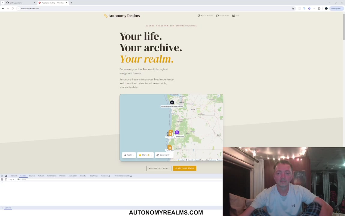
[1:53] Just go to the landing page here and you can learn more about it, but what I want to show
[1:59] you is one of the ways that it can be used.
[2:04] Autonomy Realms is a system that takes your lived experience and it turns it into what
[2:09] I call signals.
[2:12] Those signals can have GPS data attached to them and because of that you can plot them
[2:18] on a map.
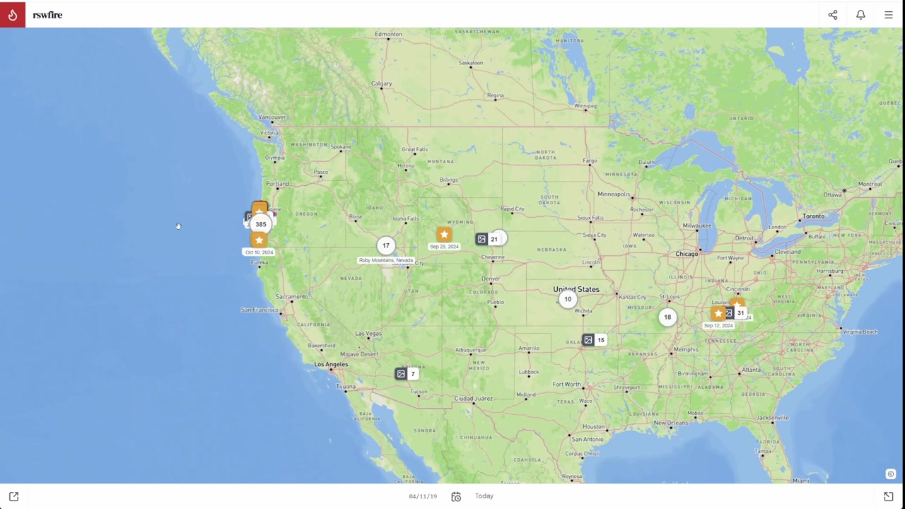
[2:19] That's what we're looking at here, we're looking at signals that are public, because this is
[2:23] the public commons map, this is the map that we all share together, so if somebody else
[2:29] has their own realm on this platform, their signals will appear on this map anywhere in
[2:34] the world.
[2:35] I can just see this filling up one day with activity, I think that would be really awesome
[2:41] to witness.
[2:42] Over here, you'll mostly just see myself.
[2:47] Every single thing plotted on this map is something I created, so if I click on one
[2:55] it opens up the signal display, and this is a transmission, so it's a video I created.
[3:03] I made this video back in January of 2025, it was my first day of orientation at Oregon
[3:10] State Park, so I started volunteering on this day.
[3:15] And there are other types of signals, so there's video, that was the main one, that was kind
[3:21] of what started this whole thing, I made over 900 videos and they're all on this platform,
[3:25] and they're all organized and I'll show that to you.
[3:30] But there are other types, so you can create audio recordings, and it uses the same principle
[3:34] as this, it just turns it into a transcript, that's what video does, and it gives that
[3:39] transcript to AI to analyze, and then AI can collect all this data on every video or audio
[3:47] signal you create.
[3:48] This is actually an older version, it gets more data than this now, I haven't been able
[3:54] to process my whole catalog with the most recent versions of the system, just due to
[3:59] the cost.
[4:00] I've been working on this without very much support, and that's just a whole other story
[4:08] that's reflected in MyRealm here.
[4:11] So you can go to MyRealm here and just see all my signals.
[4:19] They go back two years, I started off in Kentucky, there's a whole bunch more I've just put on
[4:25] the map here, I probably don't have GPS coordinates, but probably like 400 signals, and then I
[4:30] spent a month traveling across the country, and then I came to the coast, and that was
[4:34] like over a year ago, that was October of 2024, so like a year and a half, and all the
[4:40] signals I've created since then are on here.
[4:45] I started at the very southern coast, so October 10, 2024, that's when I first got to the coast,
[4:52] I turned this into a featured signal, so that's why you can see on this map with the
[4:55] star here, and this was the day that I arrived on the coast.
[5:02] So we made it to our first stop, it's 6 o'clock in the morning, we're going to get some fuel
[5:06] here.
[5:07] You can watch me travel across the country, down here you have this paths feature, this
[5:13] is something I'm still working on, but it kind of gives you, this is a timeline, so
[5:18] you can just go to the very next video to see what happened after that, after I arrived
[5:22] on the coast, and just keep going.
[5:24] Or you can use these things I call clusters, I'll talk about that another time.
[5:33] You can group things into places, so all of these are places where my signals have been
[5:39] plotted on the map, so like Kumbug Mountains, one of my favorite places on the coast, click
[5:44] locate and it takes us there, you can see this purple line here, that's when I hiked
[5:48] that trail, if I click on it, this is called a trace by the way, it shows I called it Sacred
[5:54] Journey, that's just what I chose to do, I did something about this mountain, and I did
[5:58] that on November 4th, 2024, all the data is in the system.
[6:02] I originally got that data using Gaia GPS, but I can take the data from Gaia GPS and
[6:10] import it into my system, other users can do the same thing, it's a feature, just that
[6:14] you can export your data from there, or other sources that use the same kind of standard
[6:20] formats and just import them into the system, and so this trail that I hiked over a year
[6:28] and a half ago is plotted on my map, with 9 other signals from different things that
[6:33] I recorded while I was there, at different times, each of these dates here, I spent November,
[6:42] December, this is kind of the time range of when I was there, that's another important
[6:46] feature of the system, over time, the more you do this, I've got over 900 signals, you
[6:56] can start using time ranges, so I can go on here, and this whole map is going to change,
[7:01] 90 days, 30 days, 7 days, 1 day, I have to get some of my signals into the system still,
[7:10] but if we go back a little ways, you know, these are just in the last 30 days, these
[7:16] smaller icons, these are photos, so you can, that's another signal type, you can take pictures,
[7:21] like I go hiking a lot, and that's what all these traces here are, these are just different
[7:26] photos that I've taken along these paths, you can click on them, see if I go on, still
[7:36] working on some of the different displays, and user experience for some of this stuff,
[7:46] this is the corridor where I live right now, so there's a lot of activity here, which is
[7:51] why you might use the time spans, you might want to focus on certain time periods, clusters
[7:57] do the same thing, so this was my journey from Kentucky to Oregon, like I just showed
[8:02] you, we can click that, and it will filter the map, according to all of those settings,
[8:07] including the dates, and see how it zoomed out on its own, and then it created this thing
[8:11] over here, this is partly what a cluster does, so that's just my journey going from Kentucky
[8:16] to Oregon, you can clear that, and just go back to the previous context that you had,
[8:23] you can minimize a lot of these windows that appear, so this is called a browser panel,
[8:31] you can minimize, this is my first time boondocking in my RV, that was in September 2024, I think
[8:36] I was in Wyoming, it's bought on the map, you can minimize this, and it will show up
[8:40] on this thing on the side, so that you can get back to it if you, just kind of like a
[8:44] little bookmark, a temporary one, if you wanted to make it more permanent, just star it, if
[8:49] you haven't encountered it, just star it, and then it's going to show up under this
[8:52] little panel right here, I'll improve this, once stars become more of a thing, I'll just
[8:57] improve this whole interface here, and you've got these ones up here, so the side panel,
[9:04] that's the details panel, if you minimize those, they just show up here, it has a notifications
[9:10] thing, so I uploaded a photo signal, I can locate it on the map, I can just click this,
[9:17] and it will find it on this map, take me right to it, but it's already been processed, it's
[9:21] completely processed, you would go into the admin to see what that's all about, and this
[9:26] is the admin, I don't think I'll, in this video, go through all of that, but I'll just
[9:32] show you, so the main feature of the system are signals, so a lot of the activity does
[9:37] happen there, and then you cluster your signals, you group signals together, and it creates
[9:45] a clustering, and you can do different things with that, and then if you cluster your clusters,
[9:49] you turn them into shapes, there's a whole system and reason behind all that, that I
[9:54] didn't even get into, because there's so much to this system that it's hard to just
[10:04] give you a linear path through it, so this is just my first attempt at trying to explain
[10:09] it, you create your own places, the traces system I was telling you about, here's where
[10:14] you would import them, Sanctum is a subscription service, so if you had like your own YouTube
[10:22] channel and you wanted to plot your videos on a map like this, in your own realm, you
[10:30] could do that, and then you could create a subscription service, and then like with my
[10:33] own system, I'll show you, so with my videos, so we're going to activate, we're already
[10:40] in, see how it says my name here, RSW Fire, we're in a realm context, so what we're looking
[10:46] at right now are all my signals, I'm going to clear this because it's a cluster, we're
[10:49] just going to close this cluster, and then you'll see, you know, I've got over 400 signals
[10:54] over here on the coast, and I have two different Sanctums here, so I have a free one and I
[10:59] have a patron one, both of them require you to sign up, but the free one is truly free,
[11:05] you're just signing up, you're just becoming a member of my community, patron gives you
[11:10] a sliding scale where you can choose anywhere between $5 and $50 a month in order to see
[11:15] signals that are in that category, and you can see here, there's 140 of them so far,
[11:19] if I click this, it'll open up this panel here on the right, showing you all the ones
[11:25] that are marked that way, and the only way to watch any of these videos is to be a member
[11:29] of that level, to be a patron subscriber, and every realm can create their own Sanctum
[11:37] tiers, you can call them whatever you want, you can have as many as you want, you do all
[11:42] of that yourself, you set that up, this is just how I organize mine, my realm, I put
[11:48] most of them under free because I want them to be semi-public, basically, but I don't
[12:00] want them to, I didn't want them to take over the public commons map, because over time
[12:09] that whole thing is, I mean, there's going to be a lot of iterating to that part, this
[12:16] is just the way that I felt mine, like I talk about a lot of sensitive things in my videos,
[12:21] I've been, like I've recorded 900 of them, a lot of them on YouTube over the course of
[12:26] the past two years, I didn't feel like it was witnessed cleanly, and I just wanted more
[12:34] safeguards to what I was sharing, I guess, and so I built this entire system around it,
[12:41] and I'm trying to put most of them under one of these Sanctum tiers, but then, you know,
[12:44] then there's the public ones, and you even have a private catacomb, because you can have,
[12:51] you can create signals just for yourself and use them to just process them with AI for
[12:57] your own purposes, I mean, there's a lot of different ways you can use this system, this,
[13:02] using it as an atlas, using it on a map is just one way, the other way is stream mode,
[13:06] and that's where you go to your own domain, so that should have actually gone to rswfire.com
[13:12] because I have my own CNAME, hopefully this is still working, I've been neglecting, I'll
[13:17] be honest, neglecting this part a little bit, I'm going to get back to this soon, I'm just
[13:21] done with some more of the atlas stuff, but here, you can see all of the same signals,
[13:28] you're still, you're around, but you're browsing it from a different context, instead of browsing
[13:32] it from a map, you're browsing it in more of this flattened, don't want to call it flattened,
[13:43] because there's just, there's a lot to this too, but you're not browsing it from a geospatial,
[13:50] you know, orientation, so all the same, you know, different documents that you might upload
[13:57] into your system, your signals, the different videos that I was, you know, that you might
[14:01] create, the transcripts and all the data, and all the things that you just saw in the
[14:06] map, just shared in a different context in a different way, there's a whole lot more
[14:14] that needs to be done with this, because one of the things, especially for people like
[14:20] me or others who create a lot of videos, I want to make them useful, essentially to
[14:27] unflatten them, because that's what YouTube does, is it just makes only your most recent
[14:31] video the most likely to be seen, everything else is basically forgotten, but you know,
[14:39] I'm trying to build a system where it feels useful and engaging, and I don't have the
[14:51] right words for it, I'm not going to explain it right now, but there's just, there's a
[14:54] lot of iterating, I'm still doing some of these things, and I'm also open to feedback,
[15:00] I guess, we can call that my introduction to Autonomy Realms for now, so if you're interested,
[15:20] please check it out, and leave a comment, let me know what you think, I'm very curious.
3:36
Marking One-Year Anniversary of OPRD Dismissal
Mar 23, 2026
0:55
Three Officers at the Work Center Gate
Mar 24, 2026
4:48
Naming Displacement as OPRD's Volunteer Mechanism
Apr 3, 2026
Wagon
Apr 4, 2026
4:47
Direct Address to OPRD After Police Visit
Apr 5, 2026
Lagoon
Apr 5, 2026
Seals on the Beach
Apr 7, 2026
Rainbow
Apr 12, 2026
Siltcoos Lake Hike
Apr 15, 2026
Mon, Apr 20, 2026
Apr 20, 2026
15:25
Introducing Autonomy Realms Through Live Demonstration
Apr 20, 2026
0:19
Handheld Capture Ends on Persistent Object
Apr 25, 2026
2:35
Mapping Mobile App Launch Against Internet Deadline
Apr 25, 2026
4:12
Rebuilding Sanctum as Members Feature
Apr 25, 2026
1:08
Marking the Eve of Summer Season
Apr 30, 2026
0:52
Weighing Camera Orientation for Capture
Apr 30, 2026
Summer at Siltcoos - Day 1
May 1, 2026
1:29
Opening a Series to Introduce Autonomy Realms
May 1, 2026
4:27
Introducing Autonomy on Trail Walk to Ocean
May 1, 2026
Summer at Siltcoos - Day 2
May 2, 2026
Summer at Siltcoos - Day 3
May 3, 2026
Summer at Siltcoos - Day 4
May 4, 2026
Final Statement to the Oregon Parks and Recreation Department
May 4, 2026
Campfire after saying goodbye.
May 4, 2026
Summer at Siltcoos: Day 6
May 6, 2026
Summer at Siltcoos: Day 7
May 7, 2026
Summer at Siltcoos: Day 8
May 8, 2026
Summer at Siltcoos: Day 9
May 9, 2026
Summer at Siltcoos: Day 10
May 10, 2026
Summer at Siltcoos: Day 12
May 12, 2026
7:58
Documenting Jeep Repossession Deadline and Ended Friendship
May 12, 2026
Publishing AI Orientation Document for Queryable Personhood
May 13, 2026
Summer at Siltcoos: Day 13
May 13, 2026
Summer at Siltcoos: Day 14
May 14, 2026
Summer at Siltcoos: Day 15
May 15, 2026
19:57
Walking to the Ocean, Announcing Autonomy Realms Launch
May 15, 2026
Summer at Siltcoos: Day 16
May 16, 2026
6:12
Introducing Autonomy Realms on Walk to the Ocean
May 18, 2026
Summer at Siltcoos: Day 19
May 19, 2026
2:46
Returning to the Lagoon Bench One Year Later
May 19, 2026
Summer at Siltcoos: Day 20
May 20, 2026
PUBLIC
April 20, 2026 rsw@rswfire.com PUBLISHED
Temp 0.30
Density 0.70
Energetic Quality
steady demonstrative momentum
Journey Phase
coherent, mid-build
Directional Vector
toward public transmission of self-built infrastructure
Narrative

He begins without a script. No pitch, no framing device — just his voice over a browser window and the admission, stated plainly at the outset, that the thing is difficult to explain and easier to show. He points once toward autonomyrealms.com for anyone who wants the mechanics underneath, then leaves the explanation behind and opens the map.

What loads is the public commons — the shared surface, open to anyone in the world with a realm. Today it is almost entirely his. Every point plotted on it is something he made. He says he can imagine it filling up one day with other people's activity, that witnessing that would be something, and then he clicks a marker and the abstraction resolves into a specific January morning in 2025: his first day of orientation at Oregon State Park, recorded as a transmission, sitting on the map where it happened. From there he sketches the other forms a signal can take — audio into transcript, transcript into analysis, photographs dropped along a hiked path — and notes, without dwelling, that what is displayed is an older processing version. The full catalog has not been rerun against the current system. The constraint is cost. He names it, says he has been building this without much support, calls it a whole other story that lives elsewhere in his realm, and moves on.

Then he leaves the commons for his own realm, and the density changes. Two years appear at once. Kentucky at the far edge, roughly four hundred signals there, many without coordinates. A month spent crossing the country. Wyoming, September 2024, his first night boondocking in the RV — he surfaces it, minimizes the panel, shows how it tucks itself into the side rail like a temporary bookmark, then how a star would make it permanent. And October 10, 2024, marked with a star on the map because he chose to feature it: the day he reached the southern Oregon coast. The clip plays for a moment. Six in the morning, first stop, going for fuel.

He navigates to Humbug Mountain because it is one of his favorite places on the coast, clicks locate, and the view travels there. A purple line lies across the terrain — a trace, imported from Gaia GPS, the format standard enough that anyone else could bring their own data in the same way. He opens it. He named it Sacred Journey. November 4, 2024. Nine other signals cluster around the same ground, recorded across November and December, and he demonstrates how the time range collapses and expands the whole map around them — ninety days, thirty, seven, one — the archive breathing in and out depending on which window he chooses to stand in.

Thirty days brings him to the present: the corridor where he currently lives, thick with recent activity, small photo icons strung along the trails he walks. He calls up the cluster he built for the Kentucky-to-Oregon crossing, and the map zooms itself out on its own to hold the whole continent, filtering everything to that one passage. He clears it. The prior context returns. Several times through this stretch he pauses to note what is still rough — the paths timeline, the display for photo signals, the star panel he will rebuild once stars become more of a thing — and each time the note is delivered as a status, not an apology, before he continues.

The admin interface is where the underlying logic shows itself: signals are the ground floor, signals gather into clusters, clusters of clusters become shapes. He says there is a whole system and reason behind that and declines to open it here, describing this as his first attempt at giving anyone a linear path through something that does not run in a line. Then Sanctum — the access architecture. He has two tiers. Free, which costs nothing and means joining his community. Patron, sliding scale, five to fifty dollars a month, gating one hundred and forty signals. He opens the panel and they list down the right side of the screen, watchable only from inside that tier. Every realm sets its own, names them whatever it wants, as many as it wants. He explains his own arrangement directly: he has recorded over nine hundred videos across two years, many of them on YouTube, many of them about sensitive things, and he states that it did not feel witnessed cleanly. He wanted more safeguards around what he was sharing. So he built the system around them. Beneath everything, a catacomb — signals made for no one, kept private, processed only with AI for his own purposes.

The last move is out of the atlas entirely. He goes to stream mode, which resolves through his own CNAME to rswfire.com, and says he hopes it still works, that he has been neglecting this part while finishing atlas work. The same signals appear, the same transcripts and documents and videos, arranged without geography. He reaches for the word flattened and rejects it mid-sentence, because flattening is the specific thing he is building against — YouTube surfacing only the most recent upload and letting everything prior go dark. He says he wants to unflatten them, then says he does not have the right words yet, and does not force one. He is still iterating. He is open to feedback. He calls it his introduction to Autonomy Realms for now, asks anyone watching to leave a comment, and says he is very curious.
Tags

autonomy realms product demonstration system architecture geospatial mapping signal archive subscription tiers platform development

Summary

rswfire records an unscripted walkthrough of Autonomy Realms, the software and infrastructure he built first for himself and then for others. He directs viewers to autonomyrealms.com for the underlying mechanics and keeps the demonstration high level.

He begins on the public commons map, noting all plotted points are currently his own, and opens a transmission recorded in January 2025 on his first orientation day volunteering at an Oregon State Park. He describes signal types — video, audio, photo, documents — each transcribed and passed to AI for analysis, and states his full catalog has not been reprocessed with current system versions due to cost.

He moves through My Realm: roughly 900 signals spanning two years, beginning in Kentucky, a month of cross-country travel, and arrival on the southern Oregon coast on October 10, 2024 (a featured signal). He demonstrates paths, clusters, places, and traces — including a November 4, 2024 hike he named Sacred Journey, imported from Gaia GPS — plus time-range filters, browser panels, minimize/star bookmarking, and the admin area.

He explains Sanctum subscription tiers: a free membership tier and a patron tier at $5–$50 sliding scale covering 140 signals, plus a private catacomb. He states he built the tiering because his YouTube material was not witnessed cleanly and he wanted safeguards.

He closes with stream mode at his CNAME domain rswfire.com, notes that portion is currently neglected, and invites feedback.

Environment

Screen-capture environment. rswfire narrates over a live browser session of Autonomy Realms, moving through the public commons map, his own realm view, the admin interface, and stream mode at rswfire.com. No physical setting is shown; the field is entirely the running software.

The geography referenced inside the interface spans Kentucky, a month-long crossing of the country including Wyoming, and the Oregon Coast — with Humbug Mountain, the southern coast arrival point of October 10, 2024, and the corridor where he currently lives all plotted as signal locations. Time ranges, traces, clusters, and Sanctum tiers are demonstrated live rather than described abstractly.

Substrate

rswfire holds the position that lived experience is structurally storable — that a life can be converted into signals, given coordinates, clustered, time-ranged, and made traversable rather than consumed and discarded. The architecture being built is an alternative to flattened feed distribution: a geospatial and temporal atlas where every prior transmission remains locatable, with sovereign access control (Sanctum tiers, catacomb) determining who witnesses what. The ontological stance is builder-first — the system was built for himself, then extended outward, and the demonstration proceeds by showing his own realm as proof rather than by pitching a product.

Actions

Performed

  • •introducing Autonomy Realms without script or pitch
  • •navigating the public commons map
  • •opening a signal display for a January 2025 transmission
  • •explaining signal types (video, audio, photo, document)
  • •switching into realm context to show his own signals
  • •opening the October 10, 2024 featured arrival signal
  • •demonstrating the paths timeline feature
  • •locating Humbug Mountain and opening the Sacred Journey trace
  • •adjusting time range filters (90/30/7/1 day)
  • •applying the Kentucky-to-Oregon cluster filter
  • •minimizing and restoring browser panels
  • •demonstrating starring and notifications
  • •entering the admin interface
  • •showing free and patron Sanctum tiers
  • •navigating to stream mode on his own domain
  • •naming unfinished areas of the system
  • •inviting comments and feedback

Referenced

  • •built the system first for himself, then for others
  • •recorded over 900 videos over two years
  • •created roughly 400 signals in Kentucky
  • •spent a month traveling across the country
  • •boondocked in the RV in Wyoming, September 2024
  • •arrived on the Oregon Coast October 10, 2024
  • •began volunteering at Oregon State Park, January 2025
  • •hiked Humbug Mountain November 4, 2024, logged as Sacred Journey
  • •recorded GPS data with Gaia GPS and imported it
  • •published videos on YouTube
  • •built Sanctum tiers as safeguards on what he shares
  • •set up a CNAME to rswfire.com
  • •worked on the system without much support
  • •deferred reprocessing the full catalog due to cost

Planned

  • •improve the star and panel interface
  • •return to stream mode development after atlas work
  • •iterate on the public commons map
  • •move most videos under Sanctum tiers
  • •reprocess the catalog with newer system versions
  • •explain clusters and shapes in a later transmission
  • •unflatten video archives so older signals stay findable
  • •collect feedback from viewers

Entities

beings
rswfire — Builder and narrator; demonstrates the system through his own realm
places
Humbug Mountain — Named place on the coast with a trace and nine associated signals
Kentucky — Origin point of the archive, roughly 400 signals
Oregon Coast — Current territory; over 400 signals plotted
Wyoming — Location of first RV boondocking signal, September 2024
systems
Autonomy Realms — The software and infrastructure being introduced
autonomyrealms.com — Landing page directed to for underlying system explanation
rswfire.com — His CNAME domain running stream mode
public commons map — Shared geospatial surface where all realms' public signals appear
Sanctum — Per-realm subscription tier system; free and patron levels shown
catacomb — Private signal layer for self-directed AI processing
stream mode — Non-geospatial browsing context on a realm's own domain
Oregon State Park — Site of January 2025 volunteer orientation, first shown signal
Gaia GPS — External source of trace data, imported via standard formats
YouTube — Prior distribution channel; named as the flattening architecture being countered
artificial intelligence — Processing layer that analyzes transcripts and generates signal data
concepts
signals — Base unit — lived experience converted to a stored, analyzable record
clusters — Grouped signals; clustered clusters become shapes
traces — Imported GPS paths plotted alongside signals
media
Sacred Journey — Named trace of the Humbug Mountain hike, November 4, 2024

Symbolic Elements

Represented archetypes or recurring motifs.

map
atlas
commons
trace
threshold
sanctum
catacomb
constellation
infrastructure
archive
corridor
mountain
coast

Ontological States

Expressed modes of being or awareness.

sovereign (realm holder controls data, tiers, domain, and access)
coherent (two years of signals hold as one navigable structure)
mid-build (system functional and running while parts remain explicitly unfinished)
transmitting (private architecture turned outward for public witness)
embedded (the builder demonstrates from inside his own archive, not from outside it)

Engaged Subsystems

Architecture engaged in this transmission.

infrastructural (the software itself is the subject and the medium)
cognitive (recursive design logic — signals to clusters to shapes)
geospatial (GPS, traces, places, time ranges as organizing axes)
archival (900+ videos, two years, retained and re-navigable)
economic (sliding-scale patron tier, cost as constraint on reprocessing)
boundary (Sanctum tiers and catacomb as calibrated access control)
relational (invitation to community, membership, and feedback)

Dominant Language

Core motifs or linguistic fields.

signals
realm / realm context
map / atlas / geospatial
clusters and traces
Sanctum and catacomb
unflatten
witnessed cleanly
iterating
Narrative

He begins without a script. No pitch, no framing device — just his voice over a browser window and the admission, stated plainly at the outset, that the thing is difficult to explain and easier to show. He points once toward autonomyrealms.com for anyone who wants the mechanics underneath, then leaves the explanation behind and opens the map.

What loads is the public commons — the shared surface, open to anyone in the world with a realm. Today it is almost entirely his. Every point plotted on it is something he made. He says he can imagine it filling up one day with other people's activity, that witnessing that would be something, and then he clicks a marker and the abstraction resolves into a specific January morning in 2025: his first day of orientation at Oregon State Park, recorded as a transmission, sitting on the map where it happened. From there he sketches the other forms a signal can take — audio into transcript, transcript into analysis, photographs dropped along a hiked path — and notes, without dwelling, that what is displayed is an older processing version. The full catalog has not been rerun against the current system. The constraint is cost. He names it, says he has been building this without much support, calls it a whole other story that lives elsewhere in his realm, and moves on.

Then he leaves the commons for his own realm, and the density changes. Two years appear at once. Kentucky at the far edge, roughly four hundred signals there, many without coordinates. A month spent crossing the country. Wyoming, September 2024, his first night boondocking in the RV — he surfaces it, minimizes the panel, shows how it tucks itself into the side rail like a temporary bookmark, then how a star would make it permanent. And October 10, 2024, marked with a star on the map because he chose to feature it: the day he reached the southern Oregon coast. The clip plays for a moment. Six in the morning, first stop, going for fuel.

He navigates to Humbug Mountain because it is one of his favorite places on the coast, clicks locate, and the view travels there. A purple line lies across the terrain — a trace, imported from Gaia GPS, the format standard enough that anyone else could bring their own data in the same way. He opens it. He named it Sacred Journey. November 4, 2024. Nine other signals cluster around the same ground, recorded across November and December, and he demonstrates how the time range collapses and expands the whole map around them — ninety days, thirty, seven, one — the archive breathing in and out depending on which window he chooses to stand in.

Thirty days brings him to the present: the corridor where he currently lives, thick with recent activity, small photo icons strung along the trails he walks. He calls up the cluster he built for the Kentucky-to-Oregon crossing, and the map zooms itself out on its own to hold the whole continent, filtering everything to that one passage. He clears it. The prior context returns. Several times through this stretch he pauses to note what is still rough — the paths timeline, the display for photo signals, the star panel he will rebuild once stars become more of a thing — and each time the note is delivered as a status, not an apology, before he continues.

The admin interface is where the underlying logic shows itself: signals are the ground floor, signals gather into clusters, clusters of clusters become shapes. He says there is a whole system and reason behind that and declines to open it here, describing this as his first attempt at giving anyone a linear path through something that does not run in a line. Then Sanctum — the access architecture. He has two tiers. Free, which costs nothing and means joining his community. Patron, sliding scale, five to fifty dollars a month, gating one hundred and forty signals. He opens the panel and they list down the right side of the screen, watchable only from inside that tier. Every realm sets its own, names them whatever it wants, as many as it wants. He explains his own arrangement directly: he has recorded over nine hundred videos across two years, many of them on YouTube, many of them about sensitive things, and he states that it did not feel witnessed cleanly. He wanted more safeguards around what he was sharing. So he built the system around them. Beneath everything, a catacomb — signals made for no one, kept private, processed only with AI for his own purposes.

The last move is out of the atlas entirely. He goes to stream mode, which resolves through his own CNAME to rswfire.com, and says he hopes it still works, that he has been neglecting this part while finishing atlas work. The same signals appear, the same transcripts and documents and videos, arranged without geography. He reaches for the word flattened and rejects it mid-sentence, because flattening is the specific thing he is building against — YouTube surfacing only the most recent upload and letting everything prior go dark. He says he wants to unflatten them, then says he does not have the right words yet, and does not force one. He is still iterating. He is open to feedback. He calls it his introduction to Autonomy Realms for now, asks anyone watching to leave a comment, and says he is very curious.
Mirror

You are demonstrating your own system by moving through your own life inside it. There is no script and you say so at the outset. The browser is open, the public commons map is loaded, and every plotted point on it is yours. You click one and it opens January 2025, your first day of orientation. You click another and it opens the southern coast, October 10, 2024, starred. You are not describing the architecture from outside it — you are standing inside your own archive and pointing at it while it runs.
The register holds steady throughout. You narrate, you click, you correct yourself, you note what is unfinished, you keep moving. There is no rise when you reach the featured signal and no drop when you reach the parts you call neglected. Temperature stays level across two years of material, a month-long crossing of the country, 900 videos, and the corridor where you currently live. The pace is demonstrative rather than persuasive. You are not selling; you are showing, and you state directly that showing is the only way you know to explain it.

Several subsystems are running at once and none of them is subordinate. The infrastructural is the subject and the medium simultaneously — the thing you are talking about is the thing you are talking through. The geospatial organizes: GPS, traces, places, time ranges, the 90/30/7/1-day filters that redraw the whole map as you speak. The archival holds: Kentucky to Wyoming to Humbug Mountain, the Sacred Journey trace from November 4, 2024, still locatable, still clickable. The boundary system is live and calibrated: free tier, patron tier at $5 to $50 sliding scale, 140 signals behind it, and a private catacomb underneath. The cognitive layer shows itself in the recursion you name and then set aside — signals cluster, clusters cluster into shapes, and you say there is a whole system behind that which you will not get into now.

You name constraints plainly and without elaboration. Cost is why the full catalog has not been reprocessed with the current version. Support is why the build has gone the way it has, and you mark that as another story documented elsewhere in your realm rather than telling it here. YouTube's behavior is why the stream mode exists — you state that only the most recent video is likely to be seen and everything prior is forgotten, and that you are building against that. You state that you did not feel your material was witnessed cleanly, and that you built the access control in response. Each of these is delivered as a condition of the build, at the same volume as the feature tour.

The orientation is outward. Two years of a system built for yourself, turned toward whoever is watching, with an invitation attached — check it out, leave a comment, become a member, tell me what you think. What is absent is any claim of completion. You say iterating repeatedly. You say still working on it, still improving the interface, still getting signals into the system, still don't have the right words. You do not resolve the demonstration; you stop it. The closing line is that this is your introduction for now.

Queryable Personhood

Hand your life to anything that reads.

Share this link with artificial intelligence — it reads the full transcript, analysis, and reflections. An AI-readable mirror of this signal.

The qpkey in this URL is a per-signal access token. Anyone with the URL can read the record — treat it like a share link, not a password.